We’re excited to announce a powerful new feature in the WAIV GPS tracking platform: the ability to export your rental trip routes to either GPX format or Excel files.
This gives you more flexibility in how you view, share, and archive trip data—whether you’re analyzing past routes, assisting customers, or resolving insurance claims.
WAIV provides real-time GPS tracking for boat and jet-ski rental businesses through our sleek, high-performance web app powered by Google Maps. Google Maps offers an exceptional user experience with fast loading, accurate location data, and always-up-to-date maps.
However, when it comes to navigational details like water depth, marine markers, and boating lanes, nautical maps are often more useful. That’s where our new GPX export feature shines. You can now import your boat routes into popular marine navigation apps such as:
Garmin Navionics
i-Boating (by GPS Nautical Charts)
Aqua Map, OpenCPN, and many others.
Meanwhile, Excel exports offer a structured, spreadsheet-friendly format that can be useful for:
Filing insurance claims or disputes
Operational analysis
Record keeping and audits
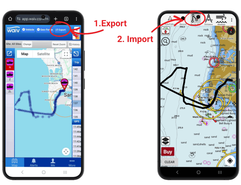
How to Export a Route to i-Boating (Step-by-Step)
Here’s how you can export a route from WAIV and view it on a nautical chart using the i-Boating app on Android:
Log in to the WAIV web app.
Select a boat from the list on the left-hand side.
Choose a trip from the list on the right-hand side. The GPS route will be displayed on the map.
Click the “Export” button at the top of the screen.
Choose “GPX format” from the export options. The GPX file will be emailed to the account holder.
Download the file to your Android phone from the email.
Open the i-Boating app by GPS Nautical Charts (Visit website).
Tap the “Route Manager” icon in the top bar.
Choose “Import Route from File”.
Select the downloaded GPX file and confirm.
Your imported route will now appear on the i-Boating nautical map for review and navigation.
Use Cases
Insurance Documentation: In case of an accident or dispute, providing a GPS track of the exact route can be invaluable.
Operational Review: See how boats are being used, assess trip durations, and plan fleet usage more efficiently.
Customer Experience: Some rental operators may choose to offer a post-trip summary map to their customers as a premium service.
Try It Today
This new feature is now live and available to all WAIV users. Whether you’re enhancing safety, improving operations, or adding value for your customers, route exporting adds a new level of insight and flexibility.
Have questions or feedback? Contact our support team at support@waiv.ai or call us at +1 (858) 935-4485.
WAIV Technologies, Inc.
4438 Ingraham St
San Diego, CA 92109
Phone: 858.935.4485
Email: contact@waiv.ai
Website: https://waiv.ai
Media Team
WAIV Technologies, Inc
+1 858-935-4485
email us here
